Gut Slobotshik, bei Neu Samara Kolonie
|
|
Ortsseiten mennonitische Guts und Gutbesitzer in Russland. Von Viktor Petkau. Bilder und Fotos mennonitische Gutbesitzer und Guts (Chutors) in Russland.
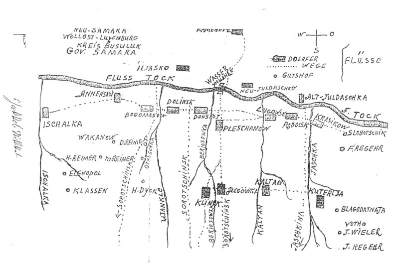
Gutsname: Slobotshik
(Gut) Ortsnummer: D0292 Koordinaten: 52.805783, 53.685810 Quellen: [26]; [125 S. 202]; [275 S. 6]; [527 S. 54] |
|
| Information und Quellen aus Orte in den Mennoniten in Russland bis 1943 lebten. | |
Quellen: |
|
77. Karte “Neu-Samara Kolonie“ by W. Schroeder. Mennonite Historical Atlas. First Edition. William Schroeder. Winnipeg. 1990. 125. Mennonite Estates in Imperial Russia. Second Edition rev. and expanded. Helmut Huebert. Winnipeg, Canada. 2008. 151. Mennonitische Orte in Russland in Google My Maps. Von Andreas Tissen und Viktor Petkau. 206. Karte "Neu Samara Kolonie" aus dem Buch: "Neu Samara am Tock, Russland- USSR. Brucks, J.H., Hooge H. Clearbrook. 1964". 275. Neu Samara am Tock (1890-2003). Eine mennonitische Ansiedlung in Russland östlich der Wolga. Brucks, J. H., Hooge H., Hrsg.: Warendorf. 2003. 527. Mennonite Historical Atlas (Second Edition). Schroeder, William, and Huebert, H T. Winnipeg. Canada. 1996. |
|
Gut Slobotshik, bei Neu Samara Kolonie in Google My Maps. Von Andreas Tissen und Viktor Petkau. |
|
| Zuletzt geändert am 16 November 2019 | |
Neu
Bildergalerie
Chortitza
Chortitza Kolonie
Molotschna
Dörfer in Russland
Bücherregal
Karten
Karten Google
Bilder u Fotos
Namen u Listen
Archive
Links
Sitemap
Spende
Letzte Änderung:
19. März 2026
19. März 2026
Besucher seit 2002:
